twitter.com/philographikon2
|
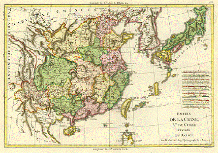
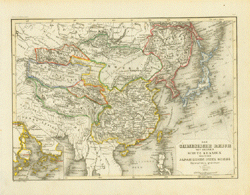
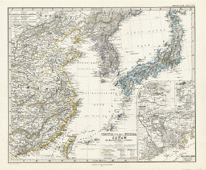
"Das Chinesische Reich mit
Seinen Schutz Staaten nebst dem Japanischen Insel
Reiche" Very interesting map of Asia showing the political divisions of the time. In the lower left is a special inset showing the area around Macao and Canton. Map was designed by J. Graessel. Published 1856. Original hand outline coloring. Vertical centerfold. Steel engraving map. Light natural age toning. Image size: 18.5 x 25.5 cm ( 7.2 x 10 ")" $95.00 Order Nr. ASIA250140 |
|
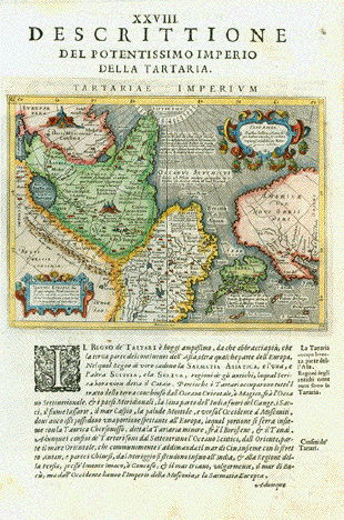
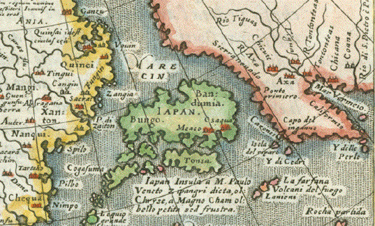
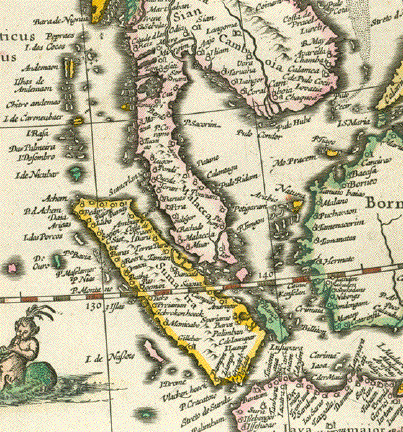
"Descrittione del Potentissimo Imperio della Tartaria - Tartariae Imperium". Plate XXVIII (28) This map shows suggestively in outlines the West Coast of North America from what later became Alaska, British Columbia, Washington (State), Oregon and California (which was already named). It also shows Japan, China, Russia, Mongolia, Central Asia. Type of print: Copper etching Artist: Girolamo Porro Published in: "Geografia cioe Descrittione Universale della Terra" Publisher: Gio. Battista & Giorgio Galignani Fratelli First published in: "Geographia" von Claudius Ptolemy Edition: Italian edition Editor: Giovanni Antonio Magini (1555-1617) Text: Italian. Complete on front and reverse side Published in: Venice Date: 1598 Measurements: Map size: Ca. 12,5 x 17 cm (ca. 4.9 x 6.7") Page size: Ca. 28,5 x 19 cm (ca. 11.2 x 7.5") Condition: Near perfect. Left margin a bit narrow. Very minor traces of age. $480.00 Order Nr. ASIAMAP236461 |
|
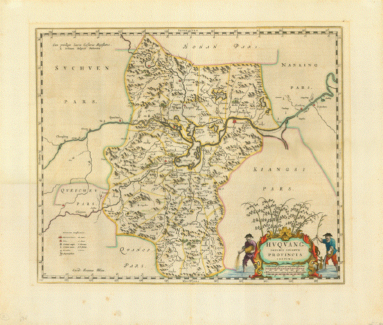
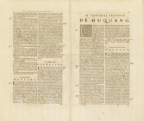
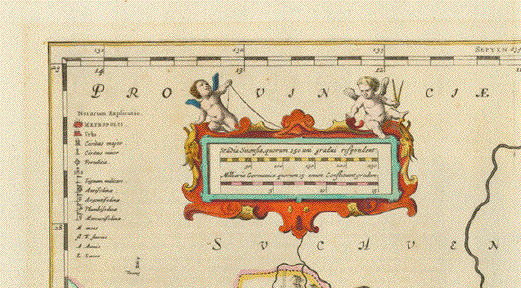
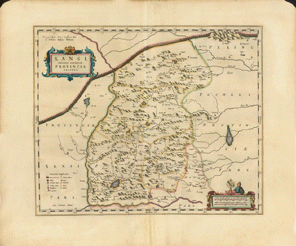
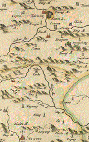
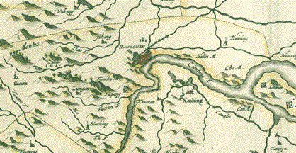
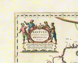
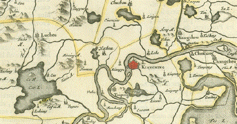
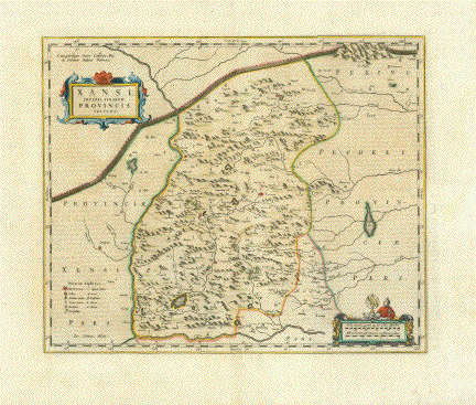
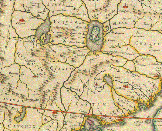
" Xansi, Imperii Sinarum Provincia Secunda". Copper etching by Wilhelm Janzoon Blaeu after Martino Martini SJ in original hand coloring. Amsterdam, ca. 1635. The province "Xansi" on this map has almost the same boundaries as the present Shan-xi with the provincial capital Tai-yuan, that is shown on the map as Taiyven. It lies west of Peking and borders on the north directly on the Great Wall of China shown in the upper part of the map. In the west and south the province borders on the Huang-he River. The Baroque cartouche in the upper left with title is attractive in its simplicity. A mileage chart is in the lower right corner. Verso: Text in French. Very clean map. The center fold has been reinforced and flattened. Small repaired tear on upper margin edge. Small repairs on upper right margin edge. 39.7 x 48.2 cm ( 15.6 x 19 ") $ 680.00 Order Nr. CHINAMAP250106 |
|
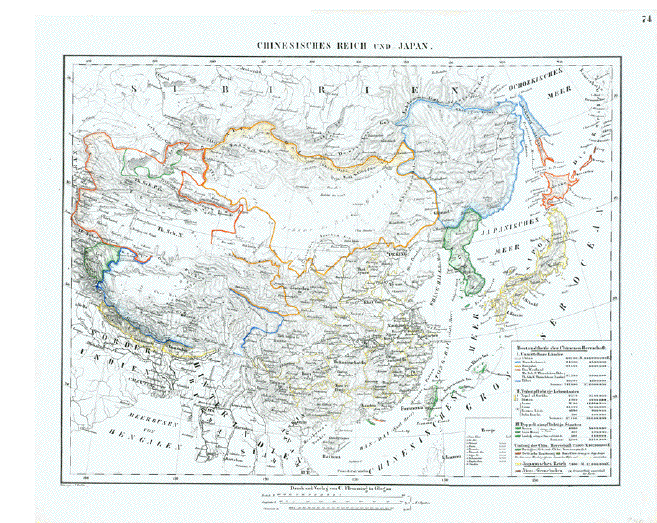
"Chinesisches Reich und Japan" Lithogaph after F. Handtke, ca 1850. Original outline coloring. Map shows topography and the
major cities and settlements of the time. Fine, clean map image. Minor signs of age and use in margins. Map image: 30.5 x 39 cm ( 12 x 15.3 ") $ 90.00 Order Nr. CHINAMAP242110 |
|
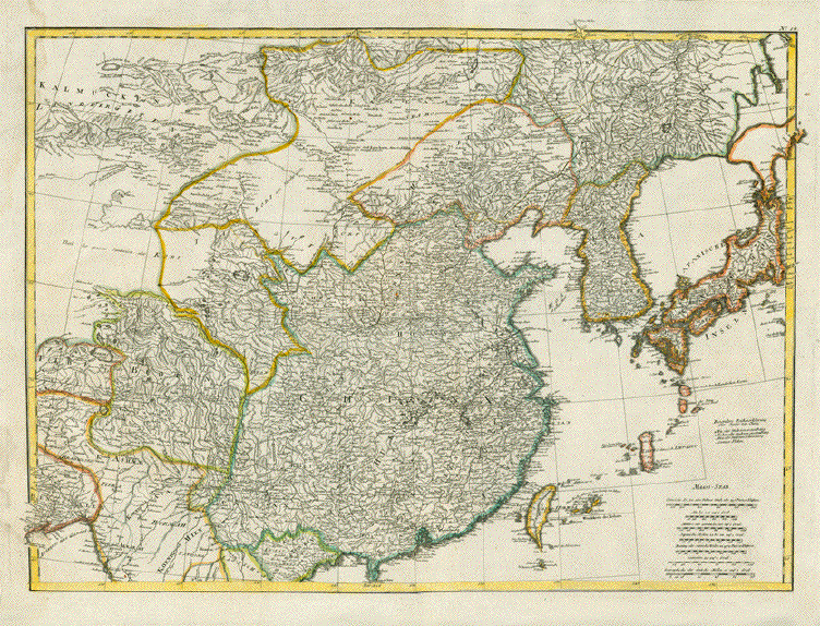
No Title Map of China that also shows part of Japan, Tartary, Taiwan, Gobi Desert and Korea. Copper etching after J. B. D'Anville by F.A. Schraembl and engraver Iacob Adam. Published in Vienna 1786. Coloured by hand at a later
date. Strong paper. Vertical centerfold has been
flattened. This is the upper part of a 2-part map of Asia. Map image: 49 x 68 cm (19.2 x 26.7 ") $ 680.00 Order Nr. CHINAMAP250722 |
|
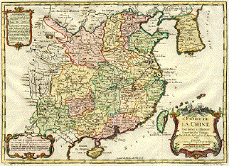
" L'Empire de La Chine". Copper etching by Bellin in attractive modern hand coloring. The map is dated 1748. A map of China with the major towns and
cities shown with a red point. Notice Korea in the north
with its major settlements. Rivers Two vertical and one horizontal fold to fit
atlas size. There is a light vertical crease from the top
margin about 10cm into image. Map is 28.6 x 40 cm ( 11.2 x 15.7 ") $ 520.00 Order Nr. CHINAMAP1688 |
|
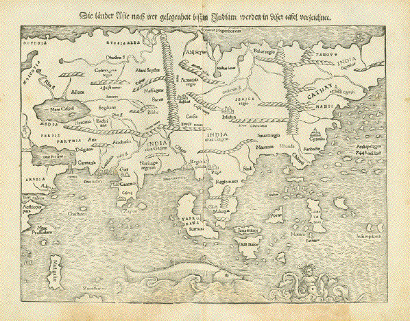
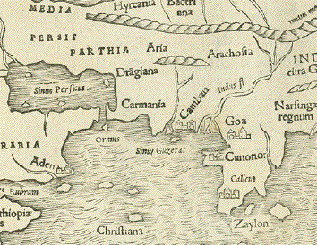
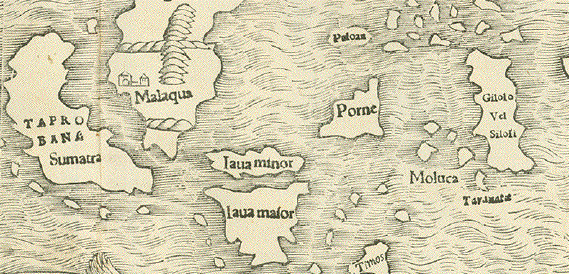
Reverse side:
"Die Länder Asie nach irer gelegenheit biss in Indiam werden in diser tafel verzeichnet" Woodcut. Published in a very early edition of "Cosmographia" by Sebastian Muenster (1488-1552) Basel, 1553 Asia as a continent in almost its entire dimension. A very early fascinating view at terra incognita. The charm of this map is the fumbling and fact-groping of huge land masses never visited nor measured nor described by geographers or travelers. Much on this map is guessing, almost nothing based on knowledge Cathay is the name Marco Polo used for China The Philippines' description is: Archipelagus 7448 insularii Siberia is India superior India itself looks like a small appendix to a huge land mass The map shows Russia, part of Arabia and Ethiopia and North Norway in the West and does not quite reach over to Kamechatka in the East. South East Asia quite prominent. Great early map to compare with reality! Light general age toning. Some little spots in margins. Lower margin has been partially reenforced. The age patina in lower margin more intense. Map: 25,8 x 34,3 cm (ca. 10.2 x 13.5") $ 1700.00 Order Nr. ASIAMAP252940 |
|
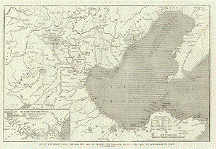
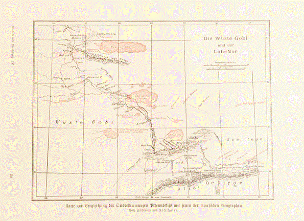
"Die Wueste Gobi und der Lob - Nor" "Karte zur Vergleichung der Ortsbestimmungen Przewalskijs mit jenen der chinesischen Geographen" Very interesting map with names given by both Przewalski and Chinese geographers. Map is after Ferdinand von Richthofen ca 1900. Text on reverse side about China exploration. Overall light natural age toning. Map image: 13 x 17.5 cm ( 5.1 x 6.8 ") $ 55.00 Order Nr. CHINAMAP251707 |
|
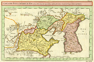
"Carta del Katy o Imperio di Kin ad uso della Storia di Jenghiz Khan riferita nella Storia Generale de'Viaggi. Tratta dagl'Inglesi.". Copper etching in modern coloring. Italian, anonymous. Ca. 1720. Italian edition of previous map. This interesting map shows the northern part of China which includes the provinces of Shantung, Hopei, Liaoning Kirin and Manchuria. In the north and northwest is Mongolia. At left center begins the Great Wall of China. All of Korea is shown with many of its former names. The map has many topographical details. The map has 3 vertical and 3 horizontal folds to fit atlas size that are almost invisible. Light overall toning. Condition is Very Good. 20 x 30.7 cm (7.9 x 12.1 ") $ 440.00 Order Nr. CHINAMAP1740 |
|
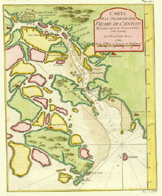
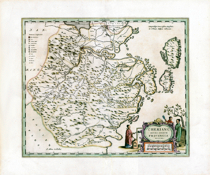
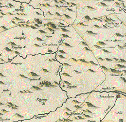
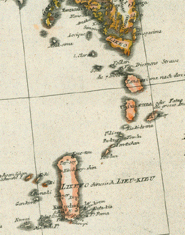
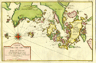
" Carta dell'Isola di Cheu Chan o Isola di Chusan". Copper etching by Bellin after Thorton. Ca. 1750. Modern hand coloring. This map is west oriented. The many islands
on this map are located across the bay from Shanghai and
belong to the province of Chekiang. Map has folds (almost invisible) to fit atlas. Except for a minimal reapired tear in the right margin, the condition is Very Good. 20.2 x 30.2 cm ( 7.9 x 11.9 ") $ 370.00 Order Nr. CHINAMAP1696 |
|
"Asiae Nova Descriptio" Copper engraving map by Abraham Ortelius. Published ca 1580. From the atlas; "Theatrum Orbis Terrarum". Original hand coloring. Text about Asia on the reverse side. Notice that Japan, the
Phippines and other islands are misprojected which adds to
the From the front this is a very
attractive map. In the upper are of the centerfold is light
browning Map image: 37 x 50 cm ( 14.5 x 19.6 ") Order Nr. ASIAMAP251961SOLD
|


|
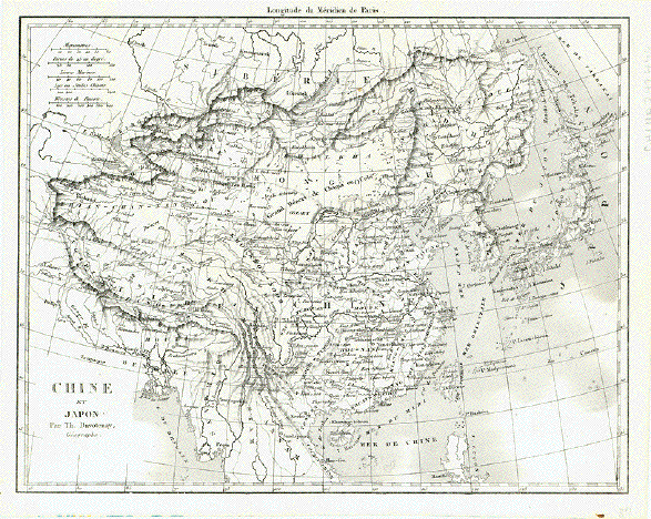
"Chine et Japon" Steel engraving by Th. Duvotenay, 1837. Folds to fit original book size. Spot in lower right margin corner, otherwise very clean. 18 x 23 cm ( 7 x 9 ") Order Nr. CHINA242476 SOLD |
|
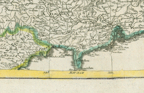
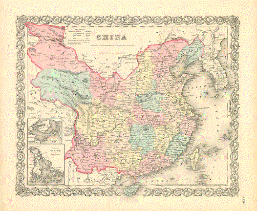
"China" Type of print: Lithograph Color: Original hand coloring Publisher: George W. Colton Published in: "Colton's Atlas of the World illustrating physical and political geography" Published: New York, 1856 Map includes all provinces in China, Korea, Taiwan (Formosa) and the island of Hainan. Map has two small insets: "Amoy" and "Canton" A decorative bordure frames this attractive map. Condition: Light general age toning. Very attractive, bright colors. Light crease in lower right margin corner without impairment to map. Reverse side is blank. 32 x 39,5 cm (ca. 12.6 x 15.6")
Order Nr. CHINA MAP 239548SOLD |
|
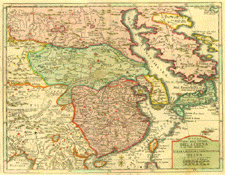
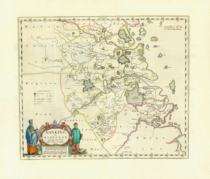
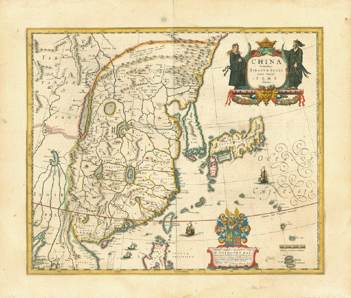
"China Veteribus Sinarum Regio nunc Incolis Tame dicta" Copper etching by Willem Janzoon Blaeu (1571-1638) Map of China, Korea, Japan, Taiwan, Northern part of the Island of Luzon (Philippines). Original hand coloring. Reverse side with explanatory text in French. Published by Joan Blaeu Amsterdam, 1634 Of Blaeu's set of maps of China
the overall China map. Beautifully originally
hand-colored. Light and pleasant age toning.
Some very minor traces of age and use in margins. 41,5 x 50 cm (ca. 16.3 x 19.7") $ 2600.00 Order Nr. CHINAMAP249016 |
|
"Asia recens summa cura delineata" Copper etching with original borderline hand coloring. Author: Henricua Hondius (1597-1651) Publisher: Johann Janssonius (1588-1664) Published in Amsterdam, 1631 Image in very good condition. Two original numbers written in ink in upper right corner. Lower margin has some
well-executed repairs, one of which reaches along centerfold
into map direction India. 37,5 x 49,5 cm (ca. 14.8 x 19.5") $1500.00 Order Nr. ASIAMAP252894 |
|
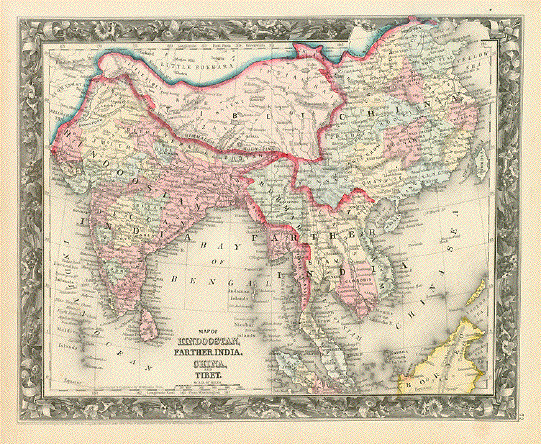
"Map Of Hindoostan, Farther India, China, and Tibet." Steel engraving from "Mitchell's New General Atlas, Containing Maps Of The Various Countries Of The World, Plans Of Cities, Etc. Embraced In Forty-Seven Quarto Maps, Forming A Series Of Seventy-Six Maps And Plans, Together With Valuable Statistical Tables." Published in Philadelphia 1860. This is from the first edition of the atlas that was published until 1893. Original hand coloring. "Farther Asia" refers to what we refer to as Southeast Asia. Margins have lght spotting. Overall pleasant light age toning. Map with border: 28.5 x 35 cm ( 11.2 x 13.7 ") $ 190.00 Order Nr. INDIAMAP239574 |
|
|
"Carte du premier periode du Monde depuis Adam jusque' a Moise ou l'on voit la Chronologie & la genealogie des premeirs patriarches avec des remarques pour conduire a l' intelligence de l' Histoire sacree." Copper engraving published by Henri Abraham Chatelain ( 1684-1743 ). The map was published ca 1730.. Original hand coloring. This interesting map shows what we call the Eastern Hemphere as it was in ancient times, On bothe sides of the map are listed key Biblical personalties with information ( in French). The map goes back to 4004 B.C. when according to the Old Testament God created man. The decorative geneological chronology around the map has the names of the Biblical persons. Map has overall pleasant age toning. Light browning along verical centerfold. 37.5 x 46.5 cm ( 14.7 x 18.3 ") $ 420.00 Order Nr. WORLDMAP240773 |

|
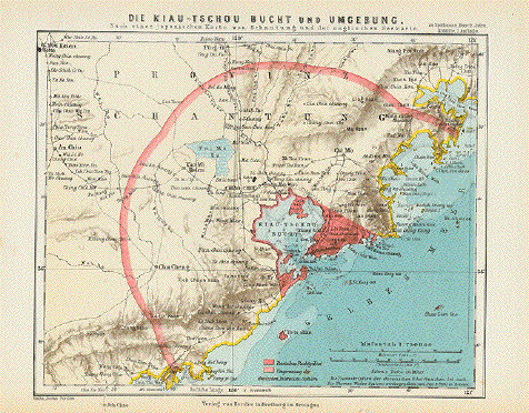
"Die Kiau - Tschou Bucht und Umgebung" ( Die Kiau - Tschou Bay and surrounding area ) Wood engraving printed in
color, 1895. This map was made after a Japanese map from
Shantung Light age toning and minor signs of age and use in margins. 18.5 x 22.5 cm ( 7.2 x 8.8 ") $ 145.00 Order Nr. CHINAMAP242215 |
|
Reverse side:
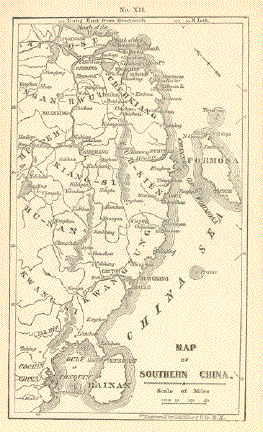
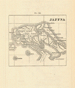
"Map of Southern China" Reverse side: Map of "Jaffna" in Ceylon Wood engraving. Printed by Schoenberg, New York City. 1867 Front side shows China coastal region from the mouth of the Yellow River south to Tonquin, the northernmost city of Vietnam. Especially the islands of Formosa (Taiwan) and Hainan are well shown as are the cities of Hong Kong, Macao, Amoy, Funchow, Shanghai. A small, but very interesting map! 21 x 12,2 cm (ca. 8.3 x 4.8") Reverse side has small map of Jaffna, the northernmost city on the island of Sri Lanka, formerly called Ceylon. 9 x 10,3 cm (ca. 3.5 x 3.9") Very light and therefore pleasant general age toning. Otherwise flawless. Order Nr. CHINAMAP239982 SOLD |
|
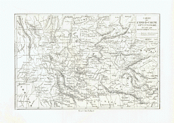
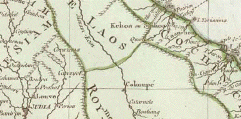
"Carte de L Indo-Chine Septrionale" Detailed map of Southeastasia.
In the center and upper right is China. Part of Myanmar (
Birma ) is in the lower left corner. Wood engraving by Erhard published 1872. Reverse side is printed. 15.5 x 23.5 cm ( 6.1 x 9.2 ") $ 80.00 Order Nr. SOUTHEASTSIAMAP240829 |
|
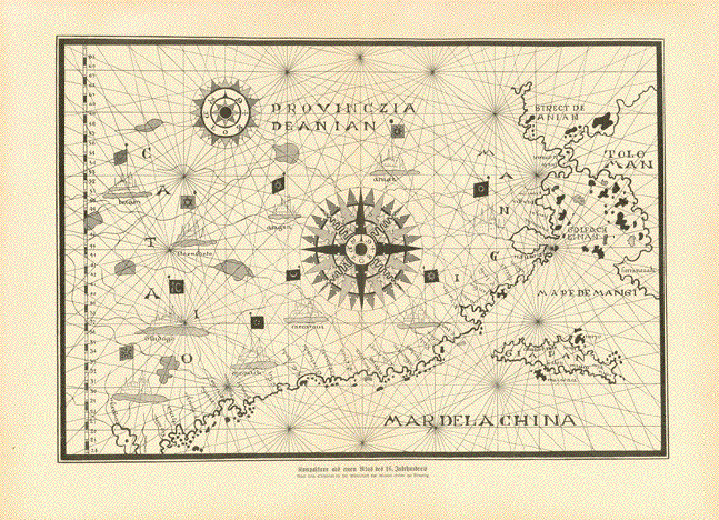
"Kompasskarte aus einem Atlas des 16 Jahrhundertsa" This is a wood engraving published ca 1900 after a map f the 16th Century in the Museo Civivo in Venice. Vertical centerfold. Reverse side is printed. Light age toning. 21.5 x 31.5 cm ( 8.5 x 12.5 ") $ 85.00 Order Nr. CHINAMAP249443 |
|
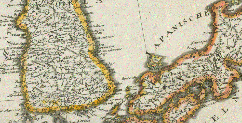
China (Oestl. Theil), Korea, und Japan Steel engraving by H. Eberhardt, Terrain and Jungmann and worked on by Erst Debes for Stieler. Dated 1871. Original outline coloring. In the lower right corner are insets showing detailed plans of Shanghai, Jedo (Tokyo) and Canton and surrounding area. The outline colors designate political boundaries according to the color key at the bottom of the map. Map is in good condition. Vertical centerfold. 33.5 x 40 cm ( 13.1 x 15.7 ") $ 145.00 Order Nr. JAPANMAP235815 |
|
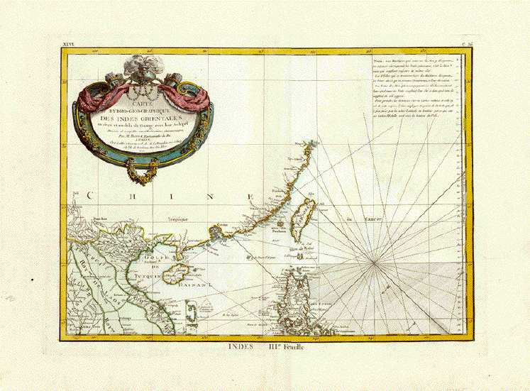
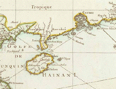
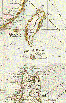
"Carte Hyro-geographique des Indes Orientales..." Copper engraving by Jean Lattré after Rigobert Bonne, the Royal Hydrographer (1727 - 1795). Beautifully decorative cartouche, very fine contemporary hand coloring (partially outline, partially general). Paris,1771. This is part 3 of a map consisting of 4 sheets. It was published in Bonne's �Atlas Moderne". The map shows south coast of China with Hong Kong and Macao, the islands of Formosa (Taiwan), Hainan and Penghu Islands. It also shows the northern part of the Philippine island Luzon, NorthVietnam, Laos and part of norther Thailand (Siam). Upper right corner is explanatory text.¸ Map is clean, has wide margins and is generally in very good condition. 28.9 x 40.4 cm (11.4 x 15.9") $390.00 Order Nr. SOUTHEASTASIAMAP251954 |
|
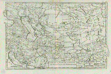
"Carte De La Perse, De La Féorgie, Et De La Tartarie Indépendante". Copper etching by André for Rigobert Bonne (1729-1795), published ca 1780. In the upper left is part of the Sea if Azow and a little below the eastern part of the Black Sea. In the upper right is part of Tartarian China. In the lower right is Tibet and Bhutan. In the lower left is the Persian Golf. Map has vertical centerfold. Very light browning along centerfold. 21 x 32 cm ( 8.2 x 12.5 ") $ 225.00 Order Nr. MIDDLEEASTMAP1865 |
|
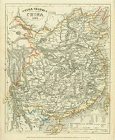
"China-Propia oder das eigentliche China 1854." Steel etching from "Neuster Zeitungs Atlas. Alter und Neuer Erdkunde" by J. Meyer, ca 1855. Original outline coloring. Very detailed map of China with its topographical and political boundaries in 1849. Notice Formosa in the lower right and Hainan at the bottom of the map image. Light age toning. 26.7 x 21.7 cm ( 10.5 x 8.5 ") $ 70.00 Order Nr. CHINAMAP1750 |